
I have no doubt as to where I am when I wake up to the sound of the saht hitting the koak-tam-kao. The foot powered pestle falling into the large mortar carved from a log is such a low solid sound it reverberates through the hard packed earth and up the posts the house is built on and into beams supporting the floor and the sleeping platform I lie on.
Usually I wake up when the eldest wife starts the fire. Today the sun is fully up and the wife of the eldest son is dehusking the rice under the house. There’s a slight creek as one end of the long pole attached to the saht is pushed down with the foot, then a hesitation as the saht at the other end tops it’s arc then that moment that hangs in time as saht falls through the air and hits the coak.
The chickens are eager to get any fallen grains, the husks will be collected to be mixed with the boiled hearts of banana trees to feed the pigs, and the family has rice for one more day of the year, one of many years, in many generations, of the people called Akha.

I rub the sleep from my eyes, grab my camera and duck underneath the house to take a photo. I know at the time it’s just a cornball tourist photo. Gotta have a picture of the foot powered saht. I’m accompanied by a couple kids and a dog, the woman is spinning cotton fibers into thread at the same time as she pushes the saht with her foot.
I saw a video shot in Vientiane by some sort of cultural preservation arm of the government, they were taking kids to see a foot powered sat tam kao. Kids in the capital can now grow up never having seen rice de husked except by machine. Gone the way of the water buffalo I guess.
This post is part of a series of posts about a long walk I did mostly in Muang Long district of Luang Namtha Province Laos in the winter of 08/09. Below are the links to the other posts.
Long Time Traveler Muang Long
One Day Treks in the Vicinity of Muang Long
Lahu NIght Out
The Trail To Nambo
Hmong House
Further Into the Forest
Ban Nam Hee
Lost in Laos

Inside breakfast is busy with lots of people. We had rice and a jeao made of toasted peanuts, hot peppers, pig oil, and enough salt to cause stroke. The headman pulled an SKS out of the roof above where I’d been sleeping, opened the magazine dropping six cartridges onto the blankets, worked the action to extract the one left in the chamber, and handed it over to one of the guys that had come to breakfast.

Tui translated. The young men had chased a large boar the day before. The wounded pig was too tough and they hadn’t been able to kill the it. One of the dogs was hurt so badly it might well die. I could picture scene in my head, young guys running around in the bushes, dogs whirling about, pig snorting and screaming, dogs barking and biting, thick brush and trees, muffled explosion of black powder muskets with lots of smoke that lingers in the slow air of the deep forest.
The hunter was borrowing the center fire rifle to finish the job today. Cartridges are expensive, probably around a dollar a piece, the headman is fine loaning out the rifle but not the ammo. The rifle is called the same thing in Laos as in the US except using mangled french consonants that come out something like Sik Kuh Say. It’s a soviet block semi auto, uses the same rounds as the AK, might well be half a century old.
A new local guide is hired. Tui, and the guides discuss the route, our old guide will return to his village and a new one will take us to Jakune Mai. I was beginning to lose track of how long we’d been out, it had only been three days and nights. This house and other houses and other cook fires in other villages in other trips seem to meld into the fires of the juggies up on the Greys river and on into the Androscoggin of my young teens.
The headman told of his difficulty kicking his addiction to opium, and his re acceptance by the people of the village. I listen with ambivalence. Opium is as much a part of their culture as the saht to dehusk the rice, it’s up to them to refrain from liking it too much. There’s more talk, of the division of the village, of the route to Jakune, of the other villages of the area.
Soon enough we were walking again. Walking was becoming the thing we do. First the local guide I called uncle, then me, and then Tui. The blister on the ball of my left foot had been hurting for a couple hours each morning, either the feeling would go away or I would stop noticing.
The walking goes easy, down hill but not steep.

By late morning were in the very large trees of the Nam Fa Valley. (nam means water or in this case river, fa is sky, so “sky river”. I’m used to very large trees and uncut forests, but the soil at the bottom of the valley is so rich the trees grow very high and the trunks are very large, some of the largest trees I’ve ever seen anywhere. The roots flare out widely to support such weight. What light filters through seems green.
I read a while ago on one of those online forums for scientific NGO workers that a Malaysian lumber company would like to build a hydro dam on the Nam Fa. The fact that the company up to this time only deals in wood is enough to make you wonder. The valley is a long long way from anyone that needs large amounts of electricity.
We took a break at a trail junction. To our left was the path to Mongla an unknown number of kilometers downstream on the south bank of the river. At least here was a route to somewhere I’d been before. I remember Mongla as it was when I left it over two years before, the morning mists so thick and heavy everything was dripping, the soft spoken Naiban and his very pretty young second wife not yet with a child.
I put on my flip flops to protect me from stones bruising my feet and used a couple of poles to steady myself. The Nam Fa was as I remember, knee to mid thigh deep, very fast, and fifty meters wide. In this land of deep forest the river is open to the sky and reflects blue. There is the musty wet smell of a big river.

From the water marks on the bank it looks as if the common high water in the wet season is four feet deeper. With six feet of water coursing through, the river would be impossible to cross for many months of the year. In a place where all travel is by foot an impassable river would create a long barrier.
For a while we just look at the river. The Nam Fa is only navigable in portions, it provides no access as a transportation route. The place where it enters the Mekong is difficult to see, it joins in the middle of a set of rapids, the sandbar pushed up by the confluence is high. I have looked for the entrance a couple of times, it hides itself well. The Fa joins the Mekong just below Xiengkok, someone had to point to it for me to see.
Across the river we walk to a village high above the flood plain. I’m not real happy. We still aren’t close to Jakune, the village is another one neither Tui nor I have ever heard of. It’s called Ban Jungah Mai, the Naiban is only 22yrs old, and he also is named Tui. I don’t know which is more unusual that a small village had such a young headman or that an Akha guy had a Lao name.
I headed under the shade of the house and watched a woman weaving while Tui made arrangements for us to continue on towards Jakune. It’s always a problem with a guide, they want to return to their village, the further they walked the more they want to ditch you and head back.

We headed back downhill towards the river but at right angles to the direction we’d come up. After an hour in the mid afternoon hot sun we reach a tributary just before if joins the main river and miraculously two boats.
It’s difficult to describe how startling it was to see boats. The valley we were in is remote in large part due to the impassable rapids up and downstream. The peoples are Akha, Hmong, Lahu, yet here were some Lu with boats.
The Lu are a type of “Tai” peoples, sharing a similar language to the Thai, Lao, Thai Nua, Dai, etc., and also sharing a similar Teravada Bhudism, similar writing systems, etc. These young guys were River Lu. The kind of Lu who live along rivers and are specialists with boats and fishing. Never before had any Lu lived along the middle portions of the Nam Fa.

Our new guide and a few of his friends and their wives and children had hiked in carrying their tools and built the boats on site where they used them in the few miles with navigable rapids. They also built a water wheel to power their sat tam kao to relieve the women of one daily chore.
Very quickly the boats are down the four kilometers to the landing for the trail to Jakune Mai. Tui and our new guide know each other. Tui used to teach high school and the guide was one of his students.
As we walk up the hill and Tui and the guide talk, I notice that the long muzzle loader our guide is casually carrying over his shoulder is pointed straight backwards and into my face. Interrupting I start to ask Tui if there isn’t some sort of safer walking arrangement and with a couple quick words they put me in the front of our little band. Tui explains the locals have never had any training. I’d guess all that would be needed would be for the hammer to catch on a twig. Call my a nervous Nellie if you will.

We head uphill. The grade is fairly steep and continuous. Afternoon turns to dusk and the guide leaves us to jog back to the river while there is light. The trail is well used and obvious. Dusk lingers in twilight then it’s dark. I turn on my headlamp and Tui switches on his flashlight which flickers for a while before dying. I figure now is as good a time as any to start talking about snakes.
I don’t like walking at nights, I much prefer sitting, or sleeping. We got to Jakune Mai before it was very late, I doubt it was much past seven or eight. Walked right on through the village without people noticing much, there are no lights, we’re just a couple more people wandering around in the dark. Dogs didn’t even bark. Maybe we smelled like everyone else.
Despite the dark, finding our way to Law Pao’s house was obvious, the village lies on a grade and the house is situated at a certain angle. For the first time in a few days I was in a place I’d been before.

Usually I wake up when the eldest wife starts the fire. Today the sun is fully up and the wife of the eldest son is dehusking the rice under the house. There’s a slight creek as one end of the long pole attached to the saht is pushed down with the foot, then a hesitation as the saht at the other end tops it’s arc then that moment that hangs in time as saht falls through the air and hits the coak.
The chickens are eager to get any fallen grains, the husks will be collected to be mixed with the boiled hearts of banana trees to feed the pigs, and the family has rice for one more day of the year, one of many years, in many generations, of the people called Akha.

Koak tam kao, and in her hand the cotton she is twisting into thread, notice the rice bag that is actually an old fertilizer bag bought from town, it still has the markings 18-20-0 representing how much NPK.
I rub the sleep from my eyes, grab my camera and duck underneath the house to take a photo. I know at the time it’s just a cornball tourist photo. Gotta have a picture of the foot powered saht. I’m accompanied by a couple kids and a dog, the woman is spinning cotton fibers into thread at the same time as she pushes the saht with her foot.
I saw a video shot in Vientiane by some sort of cultural preservation arm of the government, they were taking kids to see a foot powered sat tam kao. Kids in the capital can now grow up never having seen rice de husked except by machine. Gone the way of the water buffalo I guess.
This post is part of a series of posts about a long walk I did mostly in Muang Long district of Luang Namtha Province Laos in the winter of 08/09. Below are the links to the other posts.
Long Time Traveler Muang Long
One Day Treks in the Vicinity of Muang Long
Lahu NIght Out
The Trail To Nambo
Hmong House
Further Into the Forest
Ban Nam Hee
Lost in Laos

On the left the Naiban of ban Huay Poong, on the right the local guide from Ban Nam Hee
Inside breakfast is busy with lots of people. We had rice and a jeao made of toasted peanuts, hot peppers, pig oil, and enough salt to cause stroke. The headman pulled an SKS out of the roof above where I’d been sleeping, opened the magazine dropping six cartridges onto the blankets, worked the action to extract the one left in the chamber, and handed it over to one of the guys that had come to breakfast.

Young hunter with SKS
Tui translated. The young men had chased a large boar the day before. The wounded pig was too tough and they hadn’t been able to kill the it. One of the dogs was hurt so badly it might well die. I could picture scene in my head, young guys running around in the bushes, dogs whirling about, pig snorting and screaming, dogs barking and biting, thick brush and trees, muffled explosion of black powder muskets with lots of smoke that lingers in the slow air of the deep forest.
The hunter was borrowing the center fire rifle to finish the job today. Cartridges are expensive, probably around a dollar a piece, the headman is fine loaning out the rifle but not the ammo. The rifle is called the same thing in Laos as in the US except using mangled french consonants that come out something like Sik Kuh Say. It’s a soviet block semi auto, uses the same rounds as the AK, might well be half a century old.
A new local guide is hired. Tui, and the guides discuss the route, our old guide will return to his village and a new one will take us to Jakune Mai. I was beginning to lose track of how long we’d been out, it had only been three days and nights. This house and other houses and other cook fires in other villages in other trips seem to meld into the fires of the juggies up on the Greys river and on into the Androscoggin of my young teens.
The headman told of his difficulty kicking his addiction to opium, and his re acceptance by the people of the village. I listen with ambivalence. Opium is as much a part of their culture as the saht to dehusk the rice, it’s up to them to refrain from liking it too much. There’s more talk, of the division of the village, of the route to Jakune, of the other villages of the area.
Soon enough we were walking again. Walking was becoming the thing we do. First the local guide I called uncle, then me, and then Tui. The blister on the ball of my left foot had been hurting for a couple hours each morning, either the feeling would go away or I would stop noticing.
The walking goes easy, down hill but not steep.

Not a the biggest by any means but that root flare is greater than two meters. This just happened to be where we took a break. Purple back pack on left of photo
By late morning were in the very large trees of the Nam Fa Valley. (nam means water or in this case river, fa is sky, so “sky river”. I’m used to very large trees and uncut forests, but the soil at the bottom of the valley is so rich the trees grow very high and the trunks are very large, some of the largest trees I’ve ever seen anywhere. The roots flare out widely to support such weight. What light filters through seems green.
I read a while ago on one of those online forums for scientific NGO workers that a Malaysian lumber company would like to build a hydro dam on the Nam Fa. The fact that the company up to this time only deals in wood is enough to make you wonder. The valley is a long long way from anyone that needs large amounts of electricity.
We took a break at a trail junction. To our left was the path to Mongla an unknown number of kilometers downstream on the south bank of the river. At least here was a route to somewhere I’d been before. I remember Mongla as it was when I left it over two years before, the morning mists so thick and heavy everything was dripping, the soft spoken Naiban and his very pretty young second wife not yet with a child.
I put on my flip flops to protect me from stones bruising my feet and used a couple of poles to steady myself. The Nam Fa was as I remember, knee to mid thigh deep, very fast, and fifty meters wide. In this land of deep forest the river is open to the sky and reflects blue. There is the musty wet smell of a big river.

Nam Fa means Sky River
From the water marks on the bank it looks as if the common high water in the wet season is four feet deeper. With six feet of water coursing through, the river would be impossible to cross for many months of the year. In a place where all travel is by foot an impassable river would create a long barrier.
For a while we just look at the river. The Nam Fa is only navigable in portions, it provides no access as a transportation route. The place where it enters the Mekong is difficult to see, it joins in the middle of a set of rapids, the sandbar pushed up by the confluence is high. I have looked for the entrance a couple of times, it hides itself well. The Fa joins the Mekong just below Xiengkok, someone had to point to it for me to see.
Across the river we walk to a village high above the flood plain. I’m not real happy. We still aren’t close to Jakune, the village is another one neither Tui nor I have ever heard of. It’s called Ban Jungah Mai, the Naiban is only 22yrs old, and he also is named Tui. I don’t know which is more unusual that a small village had such a young headman or that an Akha guy had a Lao name.
I headed under the shade of the house and watched a woman weaving while Tui made arrangements for us to continue on towards Jakune. It’s always a problem with a guide, they want to return to their village, the further they walked the more they want to ditch you and head back.
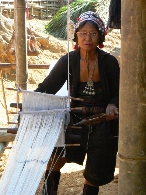
Weaving Ban Jungah Mai
We headed back downhill towards the river but at right angles to the direction we’d come up. After an hour in the mid afternoon hot sun we reach a tributary just before if joins the main river and miraculously two boats.
It’s difficult to describe how startling it was to see boats. The valley we were in is remote in large part due to the impassable rapids up and downstream. The peoples are Akha, Hmong, Lahu, yet here were some Lu with boats.
The Lu are a type of “Tai” peoples, sharing a similar language to the Thai, Lao, Thai Nua, Dai, etc., and also sharing a similar Teravada Bhudism, similar writing systems, etc. These young guys were River Lu. The kind of Lu who live along rivers and are specialists with boats and fishing. Never before had any Lu lived along the middle portions of the Nam Fa.
Boat on the middle portion of the Nam Fa
Our new guide and a few of his friends and their wives and children had hiked in carrying their tools and built the boats on site where they used them in the few miles with navigable rapids. They also built a water wheel to power their sat tam kao to relieve the women of one daily chore.
Very quickly the boats are down the four kilometers to the landing for the trail to Jakune Mai. Tui and our new guide know each other. Tui used to teach high school and the guide was one of his students.
As we walk up the hill and Tui and the guide talk, I notice that the long muzzle loader our guide is casually carrying over his shoulder is pointed straight backwards and into my face. Interrupting I start to ask Tui if there isn’t some sort of safer walking arrangement and with a couple quick words they put me in the front of our little band. Tui explains the locals have never had any training. I’d guess all that would be needed would be for the hammer to catch on a twig. Call my a nervous Nellie if you will.

Local Lu Guide
We head uphill. The grade is fairly steep and continuous. Afternoon turns to dusk and the guide leaves us to jog back to the river while there is light. The trail is well used and obvious. Dusk lingers in twilight then it’s dark. I turn on my headlamp and Tui switches on his flashlight which flickers for a while before dying. I figure now is as good a time as any to start talking about snakes.
I don’t like walking at nights, I much prefer sitting, or sleeping. We got to Jakune Mai before it was very late, I doubt it was much past seven or eight. Walked right on through the village without people noticing much, there are no lights, we’re just a couple more people wandering around in the dark. Dogs didn’t even bark. Maybe we smelled like everyone else.
Despite the dark, finding our way to Law Pao’s house was obvious, the village lies on a grade and the house is situated at a certain angle. For the first time in a few days I was in a place I’d been before.

Village Swing in the Morning Fog


